Exploring Nainital
History of Nainital
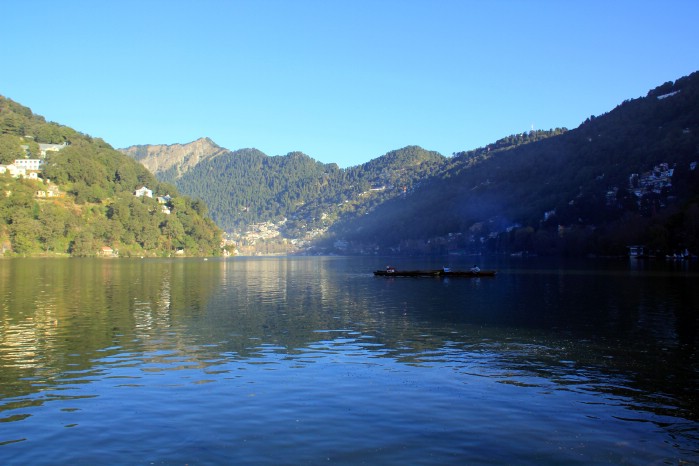
Nainital, a 100 year old hill station is in a valley near Naini Lake - a blue green lake surrounded by hills on all sides and named after Goddess Naini after which the town takes its name. It is a beautiful hill district nestled in the lap of the Central Himalayas in the Kumaon region. It's subtle yet pristine glory is manifested in the lofty snow-capped peaks, green valleys and serene lakes that have tempted lovers of beauty since time immemorial.
Nainital also has a 100 year old Raj Bhawan Golf Course for the golf lovers. From sightseeing to boating, golfing to adventure sports, from long walks and soft treks to just unwinding or introspecting Nainital, in the Kumaon region offers it all. This hill town is a photographer's delight, an artist's dream and a writer's inspiration.
Sightseeing In Nainital
The Snow view point located at height of 2270 meter on the Sher-ka-Danda hill is the most easily accessible, if not on foot then via the cable car that skims its surface and whisks you away merrily to the top. Once there you can only gaze in wonder at the glittering panorama of Himalayan snows spanning the distant horizon.
Known as the China peak at 8,568 feet is the highest point in Nainital. It commands a superb view of the Himalayas and an intriguing bird's-eye view of Nainital. One can walk or take ponies to the peak.
Kilburi is slightly away from Nainital, about 12 kms from the main town. Located amidst green forests, it is peaceful and quiet and offers a very good view of the Himalayas.
A memorial to an English lady believed to have been killed in an air crash. The spot commands a sectional view of the town and the nearby region. The peak was known as Ayarpatta Hill.
Ayarpatta Hill is a haven of trees's oak, fir, deodar, pine and rhododendron. Some of the roads are narrow and still paved with brick. On this hill stands Gurney House, home of the great Jim Corbett, the fearless famous hunter, conservationist and writer to remember. The house was named after Corbett's father. It is now a museum of Corbett memorabilia.
Situated at a height of 1951 meters, with its famous temple, this place is reputed for its glorious sunsets. A very beautiful Hanuman mandir is at the top. Near the temple stands the Uttar Pradesh Government observatory and the Satellite Tracking Center.
The clear skies over Nainital prompted the government to setup an observatory here. The observatory has one of the most advance telescopes in India. With the help of this telescope the movement of stars, planets and other heavenly bodies can be calculated to great precision.
The attractive lake of Nainital is said to be the eyes of Sati, wife of Lord Shiva. Sati jumped into the sacrificial bonfire. Lord Shiva to mourn the death of his beloved wife carried the body across the country. The remains of her body fell at various places which today are sacred worship places for the Hindus.
Naini Tal has a small but a very beautiful Zoological garden. There are many animals kept here which includes Deers, Bears, Tigers and many more.
This church was built in 1847. A brass memorial is kept in memory of the persons who were buried in the infamous landslide.
Any visitor coming to Nainital cannot miss the joy of riding a horse on the Mall. Not only at the Mall but to reach the Snow View Point, Tiffin Top, Kilburi from the Mallital area one can hire ponies and horses.
How to Reach Nainital
By Air : Pantnagar airport, situated around 70 km from Nainital is the nearest airport, though not very well connected to other major Indian cities. Buses and private taxis are easily available from Pantnagar to reach Nainital. It is advisable, however, to travel to Delhi (nearest international airport) by air and take a train or better still, travel by a taxi to Nainital from there.
Plan your visit
A useful journey leaves room for local discoveries. Start with these essentials, then verify operational details from primary sources.
Mountain weather can shift quickly; check forecasts, road access and local advisories.
Plan for hill roads and longer journeys than the map may suggest; use reliable licensed transport.
Explore nearby walks, viewpoints and markets without overloading a single day.
Carry waste out, respect fragile ecosystems and follow any trekking restrictions.
More journeys to discover
Frequently asked questions
What is Nainital known for?
Nainital is explored in this guide through its local heritage, visitor attractions, culture and images. The highlights and linked articles below offer starting points for your itinerary.
How should I plan a first visit to Nainital?
Choose a few nearby highlights in Nainital, group them by area and allow flexibility for travel, meals and rest. Confirm the latest access information with official providers.
When is the best time to visit Nainital?
The most comfortable time depends on local weather, festivals and your planned activities. Check current seasonal forecasts and any attraction-specific closure notices for Nainital.
Where can I confirm ticket prices and opening times in Nainital?
Check the official tourism authority or the individual venue before departure. This page intentionally does not repeat potentially outdated prices or hours.
Is this Nainital guide updated?
This page was rebuilt from legacy IndiaCityTrip content on October 23, 2026. Older descriptive material has been reorganized; operational details still require direct verification.